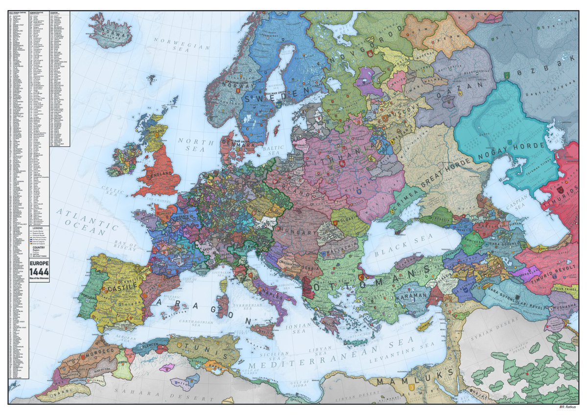
Avrupa’nın 1444 yılındaki siyasi haritası. https://t.co/T7raCx1PXC
LEGEND Ca COUNTRY EUROPE 1444 of the THAN ATLANTIC OCEAN SEEDS MARRAS 8FM5 PORTUDAD ORWA CELTIC CARLA Leik MOROCCO BRILMASA CASTILE PARA 365-144 BAY OF BISCAY EXTRA STOLES mald Juan ALBORAN SEA NORWEGIAN SEA SORTLAND ENGLAND THE CHANNEL Descans Si A TLEMCEN NORTH SEA BALEARIC TEAT La gr THAN LETTER A ZAR G CARTHAGINIAN OTUNI www. LIGURIAN SEA GAR FORWA SAHARA DESERT 6E ENMA MARK 10 SWEDE FOR YRRHENIAN BOHEMIAL N BALTIC SEA CPEF OF GARES Tigelas P Extendran 28 HUNGARY ADRIATIC SEA NAPLES D AMORTIC SICILIAN SEAP REVENTO ND SERE 1N SEA LITHUANIA 700 Ben GULF OF SIDRA Fire Pergian “8” F Fratets KEES Derning Log JOIA 0²- MOLDAVIA RELATEERD VER The PE Ratars BALLACHIA LEATHER z OTT P 0 ALICH LIBYAN DESERT ORTATAN A GMARI SCOVY wikk EM LIBYAN SEA MEDITERRANEAN SEA MUSEONE ****** BLACK SEA Ath. afera CHICA WALMARY A N S DA KARAMAN SPERM SEP THE LEVANTINE SEA ***** ringa 1-M/F WAL da MANA MAMLUKS SULKADIN taka
The photo is a detailed map of Europe in 1444. It shows the various kingdoms, principalities, and territories that existed at that time, colored and labeled to distinguish them. There are also various tribal groups and smaller entities marked. The map's detail is quite high, showing the political divisions of the era. There's no joke *inherent* in the map itself. The map is a historical document, not a humorous one. To understand a joke in Turkish, you would need to have the *context* of the map being used in a humorous or satirical way, *in conjunction* with some other text or situation. A joke might be made about specific political entities or their relative sizes on the map in comparison to today, but without additional information, there is no joke present in this image alone.
Henüz bişi yazılmamış