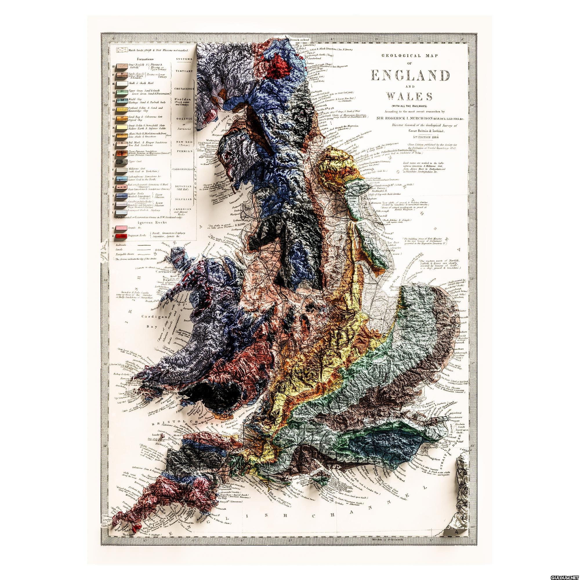
7. England And Wales Map, Relief Map
Marsh lands (Brit & Post Pliocene not marked
Formations
18 Norfolk & Pliocene &
SYSTEMS
Mioone or
Upper Tertiary
TERTIARY
177 Soca or Lo
Tatiars
Chalk & Chalk Marl
Berwick on Tweed
off in Limestone)
Schist & Black Limestone/See Devon
"Banborough Castle/Trap
Sunderland
Hastings Sand & Purbeck beds
13
Portland Oolite & Sand and
Kimmeridge Clay
15 Upper Green Sand & Gault
Lower Green Sand &Neocomian)
Would Clay
CRETACEOUS
Wealden
(Fresh water
and Estuary)
Geral Rag & Calcareous Grit
Oxford day
OOLITIC
Great Oolite & Stonesfield State
Fullers Earth & Injoner Oolite
Jurassic
Alum Shale & Marlstone with Iron
Lias shale & limestone
SOLWAY FIRTH
Maryport
Red Marl & Keuper Sandstone
New Red Sandstone
NEW RED
Workington
(Trias)
PERMIAN
Matelaves
Bees Hards
Timas
Granite
Upper Coul
Millstone Gnt
(with Coal in Yorkshire)
Carboniferous Limestone &
aer God in the North
Red conglomerate Comstone & Marl
Sate Limestone & Sandstone Devon))
Ludlow Rocks
Upper
Wenlock Limestone) Silurian
Candy bola Rocks)
Lower
glomoment Halash Inalacr
CARBONIFEROU
DEVONIAN
(old Rod)
SILURIAN
CAMBRIAN
and altered
Rece
Fundamental or Laurentian fineins in NW Scotland only)
Igneous Rocks
Pures in
nglast
Bo
Li
One!
in Low Walney1
fillan Beevein Backd
Bay
Lancaster
Rete
Pl
Blackpool
Lytham
>>>
Say shells in gravel
Trappen Rod
Serpentine, Syenite de
(Basalt, Greenstone Porphyry
R Ribble
Southport
Railroads
Canals
Sherry L
Navigable Rivers
The Arrows indicate the dip of the strata
S
Formby
Helbre
Bay
(and intent Abertha
Caernarvon
Bays
Spondon & Pals fonts
use of the Ganador
or Shelly Sandstone of Shropshire
7
Brachy Pl
Bardsey
Cardigane
Bay
Towyn
Aberystwith
Slaty
Llanhysted
Aberer
Teatrumand
Newport
Pahand
Strumble
ddy Baye
Lingula
Bishop&Gorks: 5
Gratho
pet af
the
RB
P.Eynom
BRISTO
C
L
Hangma
Forth i
2.
River Severn
Lady
prod
Hartland pe
chists
and but
Bude lar
Cal State & Magnone.
shelly sands
long the Tete
pe
Rad and in Mari
Sandstone
elmarble
Hope Nose Baired Beach!
(Devonian overtone)
Berry (Limestone)
Raient Prucher
Hurtle B
Watergate H
Gamb
alary to
mouth S
horough. (Tray)
Dr Eltone is here Magneron
Sloat in I
Namouth B
Mume
Coal Works
Xabi
Semente Coal pse in Couse Cool full
(87
sion Lime & Lower New Rot)
Shields th
undert
ic Pian
teste !! deep) Bank of Whir
hon le Spring
Kuhope
Sashame
!
in Limeston
at worked shout or Magnesi
Hartlepo
of the Tex
with Sandstones
Jamstow in th
GEOLOGICAL
OF
MAP
ENGLAND
AND
WALES
(WITH ALL THE RAILWAYS)
According to the most recent researches by
SIR RODERICK I. MURCHISON KCE.DC1 LID ERS.&c.
Director General of the Geological Survey of
so thick chills of liar with Joe Jchahm
Whathy
Great Britain & Ireland.
5 EDITION 1864
First Edition published by the Society for
kin Blood Bone in the Ochitosedale HamNeon)
the Diffusion of Carl Knowlonge it-42
Kt & res of your food in Sandrine of Doll
Comphon
acknas rel
O
Lead sines are worked in the Carbo
nifer Limestone & Millstone Grit,
from Alston Moor to Derbyshire and
in Flintshire, Denbighshire be.
Flamb
Cousons/
Through white
Bridlington B
Milfs of day with Chalk deintus
chalk
Hornsea "how dates of gravel & marine deribus
and by lustrine & correctried remains.
(Bows of extinct quadrupeds in girl at
Market Wrighton)
Much detritus & shingle)
P
Humber
Low bast
The building stone of York Minster
& the new houses of Parliment
parried in the Magnesian Limestone 3)
Submarine
The eastern parts of Norfolk,
Suffolk & Essex are chiefly
covered by muses of drive",
e clay, gravel & boulders.)
(Chalk covered by
detribal
Mundesley (Chalk
ant benes)
Sandhills)
Wildbarough
Janney
ng upon
London Ga
FitDeben
flarwick
HEW The Fase Your Roll Cong
ring London Clay
atton Post
Picone
River Thames
& Custar
Varpate
Fordland
roadstairs
pamegate
Goodwin
Sands
barnt upon
Chalk
riland is
DO
Calais
ungeNess S
Jon & other Souriant
astings Hands & Fruch water shells
with Iron
and lignes
romande
formegy
Eastboure
Beachyllead
Saurin
MelcombeRag
Weymouth
Purbeck beds
rtland Odine.
Forside
"the one shingles
ampton
Chalk flind
hone
Time old pebble bale and chalks
&lock in London)
ra
th
desham
esham & Beashot bel
of love and upon bull)
Pride with Cyclade
c
H
A
S
H
1
Start
1.
G
Chlorite Sta
Kaynak
Fotoğrafta, 1864 yılında Sir Roderick Murchison tarafından hazırlanmış olan İngiltere ve Galler'in jeolojik bir haritası yer alıyor. Harita, farklı jeolojik dönemlere ait kayaçların dağılımını, yerkabuğu yapısını ve o dönemlerdeki jeolojik oluşumları gösteriyor. Renkli kodlamalar ve simgelerle zenginleştirilmiş harita, jeolojik katmanları ve oluşumları görselleştiriyor. Haritanın alt kısmında, kullanılan renklerin ve sembollerin açıklamaları mevcut. Fotoğrafta bir espri yok. Sadece bir jeolojik harita.
"Magnesian Limestone" da mı ne 😂🤣 Bu jeoloji terimleri beni deli ediyor 🤪
Bu harita daha çok bir rap şarkısı gibi 😂
Bu haritada ne aradığınızı merak ediyorum, yoksa bir bilimsel proje mi 🤓